Authors: Dale Harris, Teresa Patterson
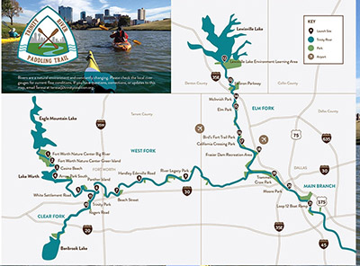
Want to paddle but the river is running too high? Too much wind or sun to paddle a lake? Just prefer the intimacy and adventure of creek paddling? We are here to help. Here is a listing of creeks and tributaries throughout the DFW area that are fun to paddle. The first part of the list contains known paddle trips that we have personally vetted. The second part of the list contains locations that we have heard of or scouted, but not personally run.
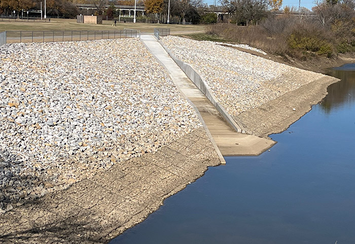
The DFW Area has 12 lakes in the surrounding Metroplex. These lakes are manmade and designed for water storage to cover drought times for north Texas. The area lakes are also open to recreation and are a good place to go when the Trinity River is flooded. During the rainy time of the years the area lakes will also fill with water and this opens some interesting and beautiful paddling opportunities on some of the creeks and tributaries. Below are some of our favorites. Be certain to check our Launch Point Access Report or call the managing park before you go to be certain your planned launch point is open.
Base criteria:
- Assumption: the lake listed is at, or near, conservation pool.
- Two miles or less lake paddling.
- At least two miles of creek paddling.
Grapevine Lake
Branch: Denton Creek
Location: Lat & Long 33.025037 -97.167747
Put-in: Marshall Creek Boat Ramp / Lat & Long DD: 33.025568 -97.179234
Description: Located at the Northwest end of Grapevine Lake. There is a $5 entry fee, a boat ramp and some picnic tables. This section is an easy paddle, going north out of the boat ramp it’s 2 miles to the lake. Going south out of the boat ramp you can go up Denton Creek for about 3 miles.
Lake Arlington
Branch: Village Creek
Location: Mouth of Village Creek Lat& Long DD: 32.672833 -97.230046
Put-in: Bowmen Springs Park Boat Ramp / Lat & Long DD: 32.687875 -97.217316
Description: This boat ramp is on the lake and about 2 miles from the entrance of Village Creek which is at the south west end of the lake. Please note the wind conditions before heading out. A wind speed of 10 MPH can cause small waves to form. Village Creek is a beautiful creek the water is typically clearer than the lake. There is very little trash and trees are overhanging the creek. It should be easy to cover 3 miles up Village Creek, perhaps a little further if you want to walk your boat through some shallow water.
Branch: Village Creek (Alternative launch)
Location: Mouth of Village Creek Lat& Long DD: 32.669168 -97.231256
Put-in: I 20 Frontage Rd / Lat & Long DD: 32.669062, -97.229285
Description: An unofficial gravel parking area off the access road with a path down to the water’s edge. Easy launch under the bridge gives direct access to Village Creek to the south, or Lake Arlington and the channel that circles Treasure Island to the north and northwest. This launch is particularly good when high winds make lake paddling too difficult. Village Creek is a beautiful creek. the water is typically clearer than the lake. There is very little trash and trees are overhanging the creek. It should be easy to cover 3 miles up Village Creek, perhaps a little further if you want to walk your boat through some shallow water.
Lake Ray Hubbard
Branch: Rowlett Creek
Location: Mouth of Rowlett Creek / Lat & Long DD: 32.874366 -96.570503
Put-in: Chaha boat ramp at John Paul Jones Park / Lat & Long DD: 32.867517 -96.546095
Description: Rowlett Creek is another beautiful creek. The mouth of the creek is approximately 2 miles west of the Chaha boat ramp. Please note the wind conditions before heading out. A wind speed of 10 MPH can cause small waves to form. An alternate put-in location is an old marina at the corner of Roan Rd and Rowlett Rd (Lat & Long DD 32.865685 -96.573375). The boat ramp is on the west side of the old marina. The parking lot is open the but the boat ramp is closed to vehicle traffic – please bring your kayak cart it’s about 175 yd walk on a paved surface.
From the old marina it is just over half a mile to Rowlett Creek. From the mouth of Rowlett Creek, you should be able to go 4+ miles of upstream. The current is very slow.
Branch Rowlett Creek (Alternative launch) at Miller Rd east of Rowlett
Location: Parking lot at Miller Rd and Rowlett Creek / Lat & Long DD: 32.893651 -96.593488
Put-in: Same as the location. There is no available boat ramp. You must put in from the back of the lot, which can be a bit slippery.
Description: This put-in is right on the creek. From there you can paddle 2 miles down to Rowlett Rd and back or 4 miles over to John Paul Jones Park and Chaha Boat Ramp.
From the Miller Rd location you can also go upstream about 2.5 miles and back. Rowlett Creek rises rapidly when it rains, but it also drops quickly so it may available to paddle when the Trinity is still has high water.
White Rock Lake
Branch: White Rock Creek
Location: Mouth of White Rock Creek / Lat & Long DD: 32.852239 -96.722762
Put-in: Boat ramp near the White Rock Boat Club / Lat & Long DD: 32.849963 -96.718065
Description: From the boat ramp it’s approximately half a mile to the mouth of White Rock Creek. From there it’s an easy paddle for about 2 miles upstream. The current is typically very slow. Over all this is about a 5-mile paddle up and back.
Joe Pool Lake
Branch: Walnut Creek (TPWD Paddle Trail)
Location: Mouth of Walnut Creek / Lat & Long DD:32.601840, -97.061106
Put-in: Lloyd Park ($15 admission) / Lat & Long DD: 32.607298, -97.063711 or / Lat & Long DD: 32.601576, -97.065211
Description: Walnut Creek Paddle Trail is 2.5 miles to HWY 360 for a 5 mile round trip. The mouth is difficult to locate from the lake but is marked with barrels with paddles if you look carefully. At conservation pool or higher it is often possible to paddle and additional mile or two before encountering a deadfall that cannot be portaged. Slow to no movement on the water. Trees over most of the trail. Turtles, beaver, wild turkey, Blue Heron, and egrets among the common wildlife.
Branch: Mountain Creek
Location: Mouth of Mountain Creek / Lat & Long DD: 32.545694, -97.057204
Put-in: Britton Park ($10 honor box) / Lat & Long DD: 32.548178, -97.053685 or / Lat & Long DD: 32.547617, -97.056925
Description: Mountain Creek enters Joe Pool Lake just south of Britton Park and continues for 1 mile until it reaches the confluence with Soap Creek (good for a short paddle), then continues for about a half mile before narrowing and continuing another 2 miles to the HWY 287 bridge. this is a very clean largely shaded paddle with only a short distance on open water. Good fishing and wildlife viewing.
Benbrook Lake
Branch: Clear Fork of the Trinity River / Lat & Long DD: 32.613202 -97.503987
Location: Mouth of the Clear Fork of the Trinity River / Lat & Long DD: 32.613202 -97.503987
Put-in: South Holiday Park Boat Ramp ($5) / Lat & Long DD: 32.61288889, -97.49741667
There are 2 boat ramps in the park. No day use. Overnight camping area. There are bathrooms nearby.
Description: The put-in on the mouth of the Clear Fork of the Trinity River. At conservation pool you should be able to paddle upstream several miles.
Branch: Mustang Creek / Lat & Long DD: 32.600657,-97.474693 or Rocky Creek / Lat and Long DD 32.596732, -97.454775
Put-in: Mustang Park, Peninsula Road ($5) / Lat & Long DD: 32.60733800, -97.47262200
There are 2 boat ramps in the park and a rocky beach. Day use allowed.
Description: Two different creek trips accessible from this park. Both offer paddling up the creek and back for at least a mile or two.
Put-in: Rocky Creek Park (gates closed since 2016 but easy to walk in to use boat ramp. Apparently closure not enforced) / Lat & Long DD: 32.59458333, -97.45347222 and ramp / Lat & Long DD: 32.60233300, -97.4595830
Description: Two different creek trips accessible from this park. Both offer paddling up the creek and back for at least two miles.
The following trips have not yet been verified. These are gleaned from area fishermen or word of mouth. If you decide to try one, please let us know any details.
Lake Lewisville
Branch: Pecan Creek
Location: Mouth of Pecan Creek / Lat & Long DD: 33.181517 -97.042269
Put-in: is Oak Point Boat Ramp / Lat & Long DD: 33.176563 -97.011107
Description: Pecan Creek is about 2 miles west across the lake from the boat ramp. The mouth is located at DD 33.181511 -97.042248. At conservation pool you can paddle upstream about 2 miles. Small creek lots of trees – slow moving water. Please note the wind conditions with 2 miles of open lake.
Branch: Hickory Creek (unverified launch and trip)
Put in: Old Alton Bridge / Lat & Long DD:33.129868, -97.079201
Location: Hickory Creek
Description: Parking area and trail to launch under bridge. Hickory Creek can be paddled downstream or upstream at most levels.
Alternative Put-in: Veal Spring Branch Trailhead / Lat & Long DD:33.120002, -97.079201
Location: Mouth of Hickory Creek / Lat & Long DD:33.120002, -97.104198
Description: Gravel parking lot and trail to water. Mouth of Hickory Creek is at the water’s edge.
Branch: Little Elm Creek (unverified launch and trip)
Put in: HWY 280 (university) Bridge / Lat & Long DD: 33.22153200, -96.94511100
Location: Mouth of Little Elm Creek / Lat & Long DD: 33.229951, -96.945982
Description: Paddle north from launch then turn east to catch the mouth of Little Elm Creek
Lake Lavon
Branch: East Fork of the Trinity River / Lat & Long DD: 33.125587 -96.539856
Location: Mouth of the East Fork of the Trinity River / Lat & Long DD: 33.125278 -96.539945
Put-in: Highland Park Dr & Boat Ramp / Lat & Long DD: 33.107847 -96.541718
Description: From the put-in it is about 1.25 miles to the mouth of the East Fork of the Trinity River. At conservation pool you should be able to paddle upstream 2+ miles.
Mountain Creek Lake
Branch: Mountain Creek
Location: Mountain Creek / Lat & Long DD: 32.711488, -96.977382
Put-in: Mountain Creek Lake Park bank / Lat & Long DD: 32.711488, -96.977382
Description: From the park paddle southeast to the mouth of Mountain Creek. At conservation pool you should be able to paddle upstream 4 miles to the Joe Pool Dam. Heavy tree coverage creates shaded secluded waterway for most of the length of the creek.
Note: As of May 1 there is a log jam just a few hundred yards north of I20 Bridge that prevents travel without portage from Mountain Creek lake to the Joe Pool Dam. The paddle is still very nice.
Branch: Mountain Creek (Alternative launch)
Location: Mountain Creek / Lat & Long DD: 32.711488, -96.977382
Put-in: Unofficial access at Camp Wisdom Rd Bridge / Lat & Long DD: 32.652093, -96.990233
Description: There is limited unofficial parking along Camp Wisdom Road by the bridge. From the bridge paddle downstream 3.6 miles to mountain Creek Lake. Stay right at creek branch for deeper channel.
Note: As of May 1 there is a log jam just a few hundred yards north of I20 Bridge that prevents travel without portage from Mountain Creek lake to the Joe Pool Dam. The paddle is still very nice.